
A Jupiter Probe Flew Past Earth and Brought Back This View of Africa
Published October 17, 2026
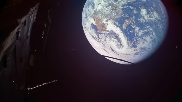
Earth during Juice's September flyby. The new JANUS Africa mosaic was released October 16 and appears below.
Image credit
Juice Earth flyby view in a landscape frame
ESA/Juice/JMC · CC BY-SA 3.0 igoDark lower part of the square source frame cropped for a landscape thumbnail. Planet and foreground spacecraft remain in the original positions and colours. CC BY-SA 3.0 IGO derivative.
ESA's new JANUS mosaic follows a strip across Africa. The September flyby also tested Juice's camera, power system and optical navigation.
From Madagascar to the Atlantic, a narrow ribbon of Earth runs through a camera test for a mission headed somewhere much farther away.
ESA released Juice's new JANUS image strip on October 16. Its frames were collected on September 28, just after the spacecraft's closest approach to Earth, and stitched into a view crossing parts of Madagascar and mainland Africa. The result is new imagery to explore, not a flyby that happened this week. ESA's image release and interactive map.
Juice is the Jupiter Icy Moons Explorer. Earth was both a gravitational waypoint and a useful place to exercise instruments before their eventual work in the Jupiter system. A familiar planet makes an unusually good test subject: there is plenty to photograph, and a great deal is already known about what should be there.
Four Minutes of Earth, Carefully Assembled
JANUS collected the frames for this strip from approximately 11:46 to 11:50 UTC on September 28. Closest approach had been at 11:45 UTC, around 8,640 kilometers above the Indian Ocean.
About forty red, green and blue frames went into the mosaic. ESA describes a strip roughly 250 to 300 kilometers wide, running from east of Madagascar through Mozambique, Malawi, Zambia, the Democratic Republic of the Congo and Angola, then toward the Gulf of Guinea.
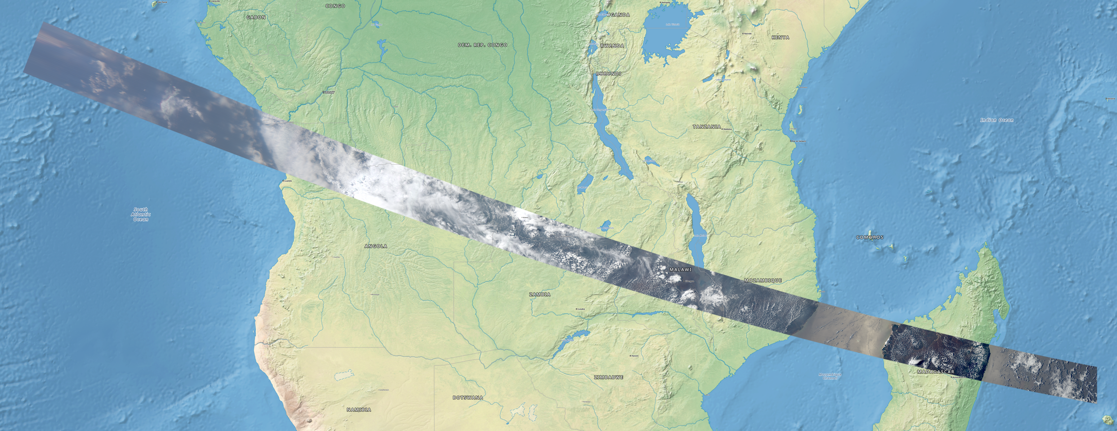
Image credit
juice-africa.png
ESA/Juice/JANUS · CC BY-SA 3.0 igoOriginal image downloaded without semantic alteration; responsive copies resized and encoded as WebP.
This is where the map is more than a decorative background. It helps the viewer relate a sequence of narrow camera views to recognizable geography. The image does not pretend that one exposure covered the continent at a single instant.
ESA's release explains that the frames were placed using spacecraft position and pointing information, with overlaps blended. That makes this a small example of a much larger imaging problem: a camera records views, while a useful mapped product also needs to know where those views belong.
Resolution Changes Along the Route
The sampling was not constant. ESA gives approximately 150 meters per pixel near Madagascar and about 375 meters per pixel over the Atlantic, as the spacecraft moved away.
Those figures describe the image sampling at different points, not a promise that every feature of that size can be identified. Clouds, atmospheric haze, viewing angle and the instrument's response all affect what can be distinguished in an actual scene.
The changing scale is worth noticing while zooming. A detail that looks smaller in a later frame may reflect geometry rather than a physical difference in the landscape. Treating the entire strip as though it were taken from one fixed altitude would erase part of the observation's context.
There is also a color-processing choice behind the apparently familiar view. Three of JANUS's thirteen filters were used for the strip. ESA says the channels were scaled together to keep the colors close to visual appearance, including the atmospheric haze. That differs from an image in which each channel has been stretched independently to emphasize particular features.
The Flyby Tested More Than the Camera
ESA's October 14 operations report describes an extended period without full sunlight: approximately three hours in Earth's full shadow and six in partial shadow. Juice's battery state fell to 54 percent, remaining above its 35 percent operational limit. ESA flight-operations report.
That is the less visible counterpart to the attractive photographs. A spacecraft has to keep its systems operating through the geometry that makes the encounter possible. A successful picture is one result inside a power, timing and communications problem.
All ten science instruments took part in the encounter. ESA also used the Earth-Moon geometry to test EAGLE, Juice's optical-navigation system. The agency says those navigation results will be analyzed over the following months; the flyby report is not a final accuracy benchmark.
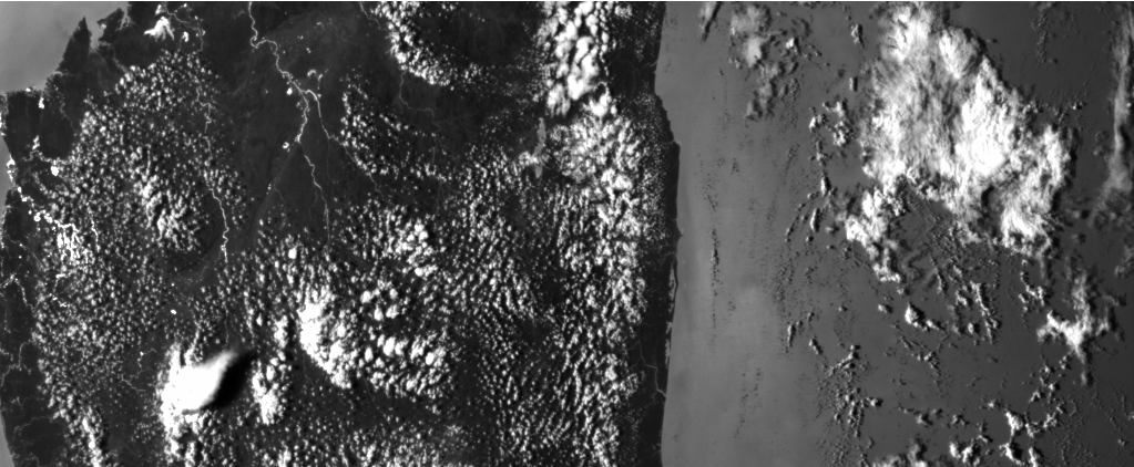
Image credit
juice-madagascar.png
ESA/Juice/NavCam · CC BY-SA 3.0 IGOOriginal image downloaded without semantic alteration; responsive copies resized and encoded as WebP.
Keeping the camera names attached to the images makes the test easier to understand. A navigation camera's job and a science camera's job can overlap in what they see without being the same measurement or data product.
A Familiar Planet as a Rehearsal
JANUS acquired 740 Earth and Moon images across all thirteen filters during its broader observing period from September 27 into October 2. The Africa strip is a selected product from that campaign, not the complete collection.
For a camera team, the value goes beyond a successful shutter command. The useful chain includes planning the views, knowing the pointing, handling changing brightness, returning the data and assembling an interpretable result. A problem anywhere along that chain can matter even when the hardware itself is healthy.
That makes the release satisfying to inspect as both a landscape and an engineering artifact. The red ground, green patches, rivers and cloud cover are the visible subjects. The changing scale and stitched edges tell another story about how a moving instrument turns a brief encounter into a map.
Open ESA's interactive version for the fine detail rather than trying to read the whole continent from a thumbnail. What would you like to see next: how the filters become a color image, or how a spacecraft navigates from camera views? Add your questions in the comments below.
Comments
Member comments are temporarily unavailable.
Log in to join the discussion.